The map
Split estate means the surface and the minerals have different owners. In Colorado, the largest share of it is private surface over federal minerals.
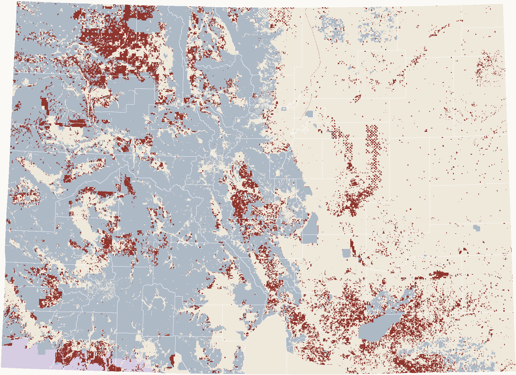
Source: BLM Colorado Surface Management Agency and Federal Mineral Estate layers (2026); Census county boundaries. Compared on a 50-meter grid.
The gray areas are what most people think of as federal land: national forests, BLM land, parks, and military land. The red areas are different. The surface there is privately owned, often ranch land, and has been for a century. The minerals under it belong to the United States.
How it happened
In the early 1900s, Congress let settlers patent western land while the United States kept some or all of the minerals. Laws in 1909 and 1910 reserved coal. A 1914 law reserved oil, gas, and certain other minerals. The Stock-Raising Homestead Act of 1916 reserved all minerals.
So the reservation is written into the patent itself, the first document in the chain. Every later deed passes the surface subject to it.
What the United States kept, within the split estate
Share of split-estate acres by type of federal mineral reservation
Source: BLM Colorado Federal Mineral Estate layer (reservation type), within split-estate areas. Calculated from mapped acres.
Where only coal was reserved, the oil and gas generally passed with the patent. Where all minerals were reserved, the oil and gas are federal. Which one applies depends on the patent.
By county
Counties with the most split estate
Acres of non-federal surface over federal minerals, top 15
Source: BLM Colorado Surface Management Agency and Federal Mineral Estate layers; Census county boundaries. Calculated from mapped acres.
Moffat and Las Animas counties each have more than 800,000 acres, about a quarter of each county. The share is much smaller in the DJ Basin. Weld County, the center of Colorado drilling, has about 54,000 acres, around 2% of the county, in scattered tracts.
Show all 64 counties as a table
Why it matters for title
- The chain starts with a reservation. The patent severs the minerals from the surface. A later deed to the surface does not carry what the patent kept back.
- The lease comes from the federal government. Federal oil and gas are leased by the BLM, not by the surface owner, and federal royalty is paid to the United States.
- Two sets of records. The surface chain is in the county records. The federal mineral side is in BLM's records: the patent, and the leases and case files for the minerals.
- The surface owner still has rights. How the surface owner and the mineral lessee work together is set by federal law, regulations, and the lease.
Where to look it up
This map shows where to look. For any particular tract, the records below are what count.
- BLM General Land Office Records: federal land patents, searchable by name or legal description. The mineral reservation appears in the patent's text.
- BLM Mineral and Land Records System (MLRS): federal oil and gas leases and case records, by serial number or land description.
- BLM's split estate page: how federal leasing works where the surface is private.
- BLM Colorado GIS data: the surface management and federal mineral estate maps used here.
- Colorado Energy and Carbon Management Commission (ECMC): wells, permits, and spacing in Colorado.
- Colorado State Land Board: state-owned minerals, a separate split estate of its own.
- County clerk and recorder: deeds, leases, and other recorded documents after the patent.
How this was measured
- Sources: BLM Colorado Surface Management Agency and BLM Colorado Federal Mineral Estate map layers, downloaded September 30, 2026; Census county boundaries.
- Method: both layers were converted to a 50-meter grid covering Colorado and compared cell by cell. Split estate here means federal minerals (any reservation type) under private, state, or local surface.
- Check: the grid gives 29.7 million acres of federal mineral estate in Colorado, including partial reservations such as coal only. BLM reports about 27 million acres of federal mineral estate in the state.
- Limits: BLM compiles these layers from sources of different ages and scales. They show general patterns, not the status of a particular tract.